|
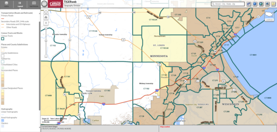
Data Update: TIGERweb Applications and Services
The U.S. Census Bureau's TIGERweb applications and services have been updated to reflect the geospatial data available as of November 2025.
TIGERweb is a collection of web-based application and service that enable users to visualize our TIGER (Topologically Integrated Geographic Encoding and Referencing system) data through:
TIGERweb Applications
TIGERweb Web Map Service (WMS)
TIGERweb Representational State Transfer (REST) Services
The TIGERweb Applications provide a simple way to view our geospatial data – including legal boundaries such as county and place; statistical boundaries such as census blocks and census tracts; roads; and other geographic features – without Geographic Information System (GIS) software and without downloading data.
The TIGERweb WMS and TIGERweb REST Services allow users to integrate our data into their own GIS or custom web-based applications.
|
|
About the Geography Program

Geography is central to the work of the Census Bureau, providing the framework for survey design, sample selection, data collection, tabulation, and dissemination. Geography provides meaning and context to statistical data.
|
|
|
|
Use of the latest and best geographic methodologies is critical to the Census Bureau’s ability to serve as the leading provider of statistical and geospatial data. Our geographic area concepts, information, and statistical data must keep pace with the needs of the researchers and analysts who work to understand the changing distribution and characteristics of our people, places, and economy.
|
|
|
|