
FALL SALE! 3 Months for 25¢Access your go-to source for essential news. Sale Ends Sept. 28 |
Atlantic hurricane season: Tropical hotspot has 80% chance of becoming Gabrielle
As we barrel into the second half of the Atlantic hurricane season, we’re still seeing relatively little tropical cyclone development so far. But the National Hurricane Center is eyeballing one nascent system of low atmospheric pressure in the mid-Atlantic.
A tropical wave of low pressure that is producing a large mess of thunderstorms in the central tropical Atlantic could become more organized and develop a rotating center, according to the hurricane center. If the system becomes a named storm, it would be called Gabrielle.
“The disturbance will begin to move into a more favorable environment for development in the next couple of days, and a tropical depression is likely to form by the middle to latter part of this week as the system moves west-northwestward at 10 to 15 mph over the central tropical Atlantic,” forecasters said in a bulletin Monday.
The hurricane center gives this tropical disturbance a 40% chance of becoming a tropical cyclone in the next 48 hours and an 80% chance over the next seven days.
READ MORE: Houston stays sunny and seasonably warm as National Hurricane Center watches distant Atlantic wave
 | Roberto Villalpando, Texas Weather Science Editor |
Justin's Five Day Fit Check
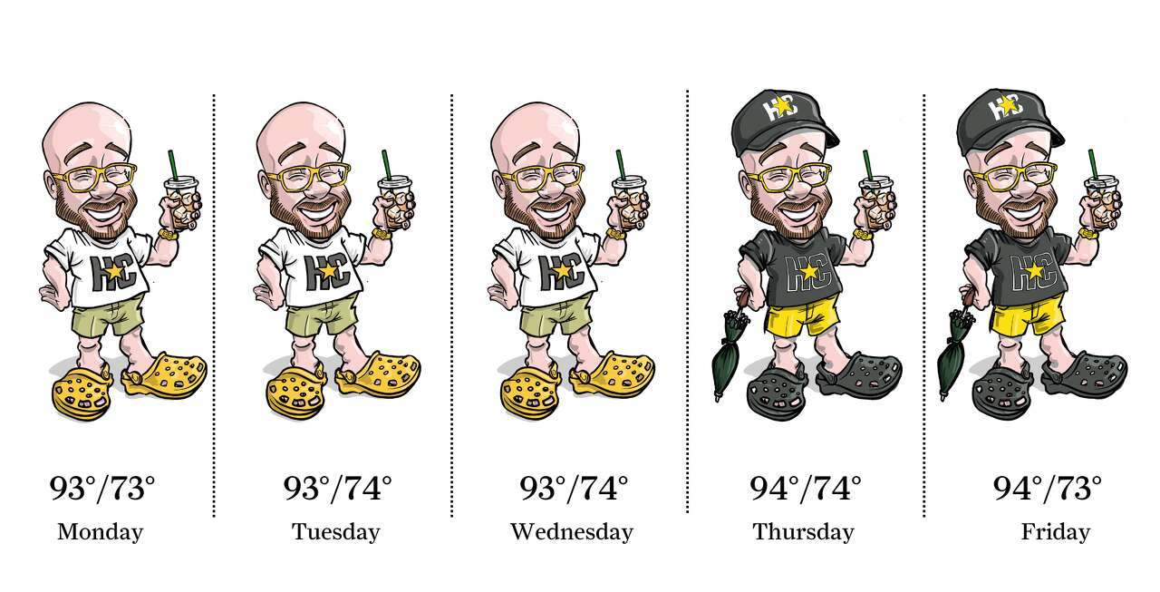
Photo by: Ken Ellis
High atmospheric pressure is still firmly in control of Southeast Texas weather this week, resulting in daily sunshine with afternoon temperatures between 93 and 96 degrees. A slight 20% chance of a stray sea breeze shower remains along the immediate coast to about 10 miles inland. As the high pressure starts to break down later this week, those sea breeze downpours may work farther inland toward Houston.
 | Ask a Meteorologist |
Jan R. asks: When you say winds are northeasterly, does that mean winds are blowing to the northeast or from the northeast?
During last week’s early taste of fall in Houston, we experienced some northeasterly winds. So, if meteorologists describe wind direction, it refers to where winds originate, not where they end up. Another way to think of it is if you’re facing north and the wind hits your face, that’s a north wind. If it’s from the east, that’s an east wind.
Even meteorology students can get tripped up at first, especially with wind barbs on weather maps. Barbs point into the wind’s origin, which feels backward, like an arrow showing where air comes from instead of where it’s going.
Why do we do this? When the world relied on sailing ships for travel and transport, it was more important to know where the wind was coming from so you could adjust the sails and exploit it for propulsion. This convention was later adopted by airplane pilots who needed to know about headwinds or tailwinds that could influence their flight mileage.
Wind direction also gives hints about future weather. For instance, if winds are coming out of the north, that typically means Houston can expect lower temperatures and an influx of drier air. Southeast winds from the Gulf of Mexico can mean more humid or rainier weather.
Do you have a Houston weather or climate question? If so, you can submit your weather questions to justin.ballard@houstonchronicle.com. They may just end up in a future edition of the weather newsletter.
Something to see
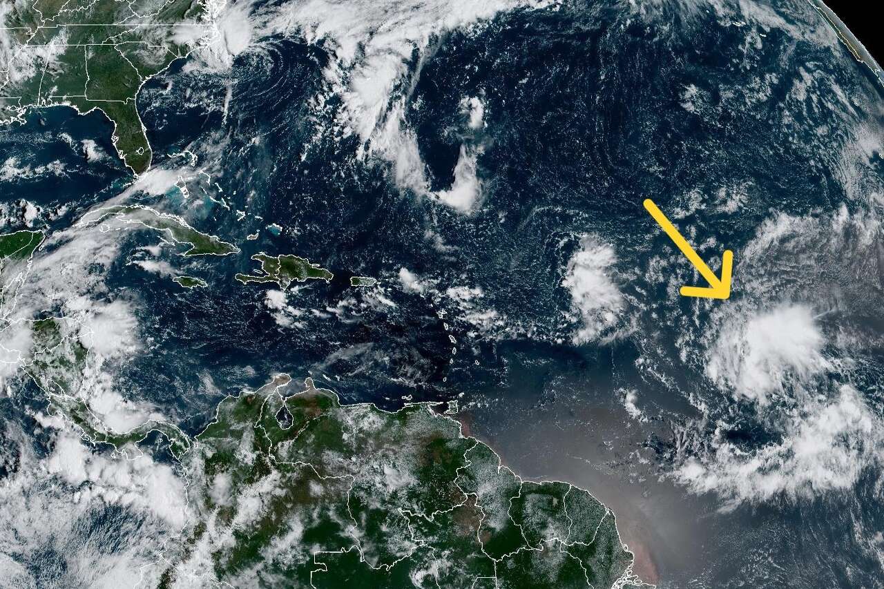
Photo by: Geostationary Operational Environmental Satellites, CIRA And NOAA
In this weather satellite photo of the tropical Atlantic Ocean taken at 8:30 a.m. Monday, we've superimposed a yellow arrow to indicate a tropical wave of low pressure that, as of Monday morning, has an 80% chance of becoming a tropical cyclone in the next seven days.
Texas Weather Wonks Trivia
September in Houston produces a climate-average of 4.71 inches of rainfall for all 30 days. But at the midpoint of September 2025, the city has logged only 0.78 inch of rain. Houston’s wettest first half of September was in 2008. What was that record month-to-date rainfall total as of Sept. 15, 2008?
A) 6.14 inches
B) 8.28 inches
C) 10.21 inches
D) 12.07 inches
Hit reply to this email to let us know what your guess is and a chance to win. We’ll let you know who answered correctly first in next week’s newsletter.
John Gutman had the correct answer to our previous trivia question: In 2023, when Houston recorded an annual total of 45 days with triple-digit temperatures, how many occurred in September? It’s C) 7 days
Other weather news
|
|
|

Meet the Team

Photo by: Susan Barber
The 713 Weather Radar newsletter is written and produced by meteorologist Justin Ballard and Texas Weather Science Editor Roberto Villalpando. You can reach out to them at justin.ballard@houstonchronicle.com and roberto.villalpando@houstonchronicle.com or by replying directly to this email.
|
Unsubscribe | Manage Preferences

Houston Chronicle
4747 Southwest Freeway, Houston, TX 77027
© 2025 Hearst Newspapers, LLC